The subsurface conditions beneath Aberdeen shift dramatically within a few hundred metres. West of the city centre, the ground is dominated by the Aberdeen Granite Formation, presenting high contact resistance and shallow bedrock. Move toward the harbour at Footdee or the industrial estates near Altens, and the profile changes entirely to saturated alluvial silts and lenses of marine clay. These contrasts in soil and rock resistivity demand a site-specific approach. Electrical resistivity surveying, using both VES and 2D profiling, maps these transitions before a single borehole is drilled. The method distinguishes between sound granite, fractured zones, and soft infilled channels. For deep foundation design in areas like Tullos, combining resistivity data with CPT testing provides a direct correlation between geophysical boundaries and geotechnical parameters. The resulting ground model supports targeted intrusive investigation, reducing the number of exploratory holes in difficult access sites across the city’s historic core.
A VES curve inversion can resolve the depth to the granite weathering front within 0.5 m accuracy when calibrated against a single borehole, slashing mobilisation costs on linear infrastructure projects.
Our approach and scope
Site-specific factors
The granite bedrock beneath central and western Aberdeen is far from homogeneous. Vertical jointing, horizontal sheet fractures, and deeply weathered troughs filled with micaceous sand act as preferential pathways for groundwater and, in contaminated land scenarios, for pollutant migration. A surface inspection tells you nothing about these features. Skipping the resistivity survey means the borehole layout is blind. You might hit sound rock at 3 m in one location and still be in soft, collapsed granite debris at 12 m just five metres away. This variability directly impacts piling refusal criteria. In the harbour area, the risk is different: pockets of organic silt with resistivity below 20 Ω·m indicate potential for differential settlement and long-term consolidation. The slope stability assessment for the steep cuttings along the A90 approach road requires accurate mapping of the rockhead profile and the groundwater table within the weathered zone. A resistivity traverse along the crest provides this model without drilling into an active slope face.
Explanatory video
Regulatory framework
BS 5930:2015 + A1:2020 Code of practice for ground investigations, Eurocode 7: BS EN 1997-2:2007 Ground investigation and testing, BS 1377 Standard Guide for Using the Direct Current Resistivity Method
Complementary services
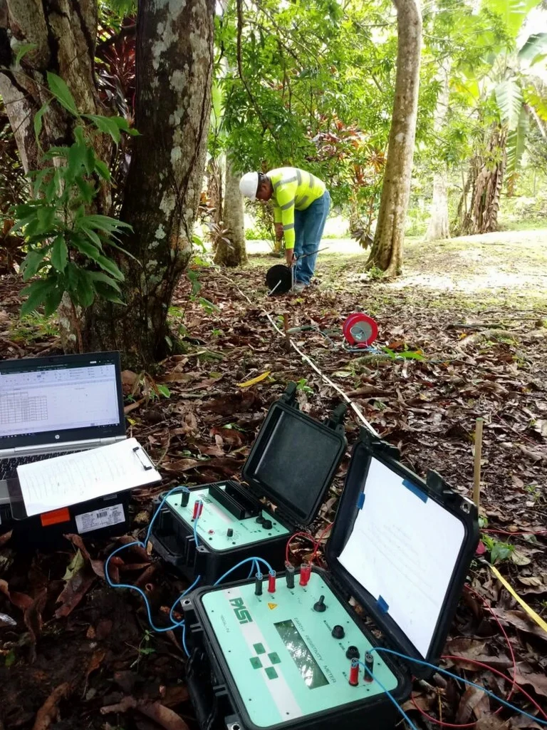
Vertical Electrical Sounding (VES)
Expanding Schlumberger array soundings at discrete locations to determine layer thickness and resistivity. Used for bedrock profiling, groundwater exploration, and aggregate resource assessment in the Dee and Don valleys.
2D Electrical Resistivity Tomography (ERT)
Multi-electrode profiles with 5 m spacing for continuous cross-sections. Applied to pipeline route investigations, embankment condition assessment, and mapping of former landfill boundaries.
Combined Geophysical and Intrusive Programme
Resistivity survey design integrated with targeted dynamic sampling. The geophysical model guides the position and depth of boreholes and trial pits, with laboratory testing of recovered samples to calibrate resistivity values.
Typical parameters
Common questions
What is the typical cost of a resistivity survey in Aberdeen?
For a single VES sounding with interpretation, the cost ranges from £520 to £890 depending on the maximum depth and site access. A full 2D ERT profile of 200 metres with multiple electrode spreads is priced on a per-line basis, typically falling within a similar range per line for standard investigation depths. The final cost depends on the number of soundings, the required array length, and the complexity of the terrain.
Can resistivity distinguish between fresh and weathered granite?
Yes, and this is one of the primary applications of the method on the Aberdeen Granite Formation. Fresh, unweathered granite typically exhibits resistivity values above 1000 Ω·m, while the weathered horizon, where feldspars have altered to clay minerals, drops to between 100 and 300 Ω·m. The transition zone is clearly identifiable on a VES curve as a distinct inflection point.
How long does a survey take and what access is needed?
A single VES sounding with a maximum AB/2 of 100 m takes approximately 45 minutes to deploy and measure. A 200 m 2D line with 5 m electrode spacing takes about 2 hours for the full sequence. The equipment requires a clear strip of ground roughly 2 m wide. The method works on tarmac, gravel, and short grass. Dense bush or rubble fill can increase the contact resistance and require pre-wetting of the electrodes.
What is the difference between VES and ERT profiling?
VES provides a one-dimensional model of resistivity versus depth at a single location. It is ideal for layered geology, such as sedimentary sequences or a simple weathering profile. ERT produces a continuous two-dimensional cross-section, resolving lateral changes. In Aberdeen, VES is often used for foundation design at individual structures, while ERT is the preferred tool for linear infrastructure like road alignments and pipeline corridors.