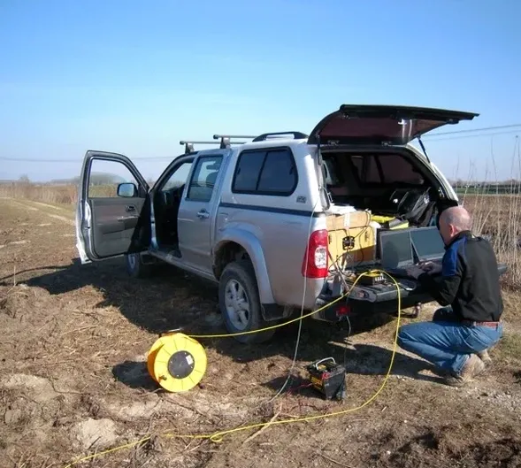
The 24-channel Geometrics Geode seismograph with a spread of 4.5 Hz vertical geophones arrives on site in Aberdeen, typically deployed along a cleared traverse across the glacial till that blankets much of the city. A 10 kg sledgehammer source on an aluminium strike plate generates a compressional wave that travels through the layered drift deposits and into the underlying Dalradian metamorphic basement — the same bedrock that shapes the topography from Kingswells to the harbour. Each shot gather records first-arrival times across the array, building a dataset that will be processed with iterative ray-tracing inversion to produce a 2D P-wave velocity cross-section. For deeper targets like buried channels or fault zones cutting the Aberdeen area, a seismic reflection setup with 48 channels and a weight-drop source recovers reflected energy from impedance contrasts at depth. The technique maps the geological structure without a single borehole, which is particularly useful in the city centre where access constraints and buried utilities limit invasive investigation. Before committing to a drilling programme, many ground engineering consultants in Aberdeen combine this geophysical imaging with test pitting to calibrate the upper two metres of the velocity model against direct visual logs.
A 2D velocity cross-section from a seismic tomography survey in Aberdeen often reveals buried channels incised into bedrock that no borehole log alone would have captured.
Our approach and scope
Site-specific factors
A recurring mistake on Aberdeen construction sites is treating the bedrock surface as a planar, gently sloping interface when in reality the Dalradian basement displays a highly irregular palaeotopography carved by Pleistocene glacial scouring. Boreholes spaced on a 20-metre grid can miss a narrow buried channel by a metre, and the designer then assumes competent rock at a uniform depth across the footing footprint. A seismic tomography line run between the boreholes detects the infilled depression as a low-velocity anomaly — often a soft, compressible clay or loose sand — that would cause differential settlement under structural load. Another local hazard is the presence of granite corestones within the weathered profile; these boulders produce high-velocity kicks in the tomogram that, if misinterpreted as the top of unweathered rock, lead to premature refusal during piling and a change of foundation methodology that no one budgeted for. The cost of remobilising a piling rig and redesigning the foundation system far exceeds the cost of a two-day seismic survey acquired early in the site investigation phase.
Regulatory framework
BS 5930:2015+A1:2020 – Code of practice for ground investigations, BS EN 1997-2:2007 (Eurocode 7) – Ground investigation and testing, BS 1377 – Standard Guide for Seismic Refraction, BS EN ISO 22475-1:2021 – Geotechnical investigation and testing
Complementary services
2D Seismic Refraction Tomography
A 24- or 48-channel array deployed with 2.5 to 5-metre geophone spacing records P-wave first arrivals. The traveltime data are inverted using a curved-ray tomography algorithm to produce a 2D velocity cross-section with depth. This is the standard method for bedrock profiling, rippability assessment, and detecting buried channels or fault zones in the Aberdeen area.
Seismic Reflection Profiling
For targets deeper than 50 metres — such as verifying the depth to the Aberdeen granite batholith or mapping major fault structures — a 48-channel reflection survey with a weight-drop or accelerated weight-drop source records reflected energy from subsurface impedance contrasts. Processing includes CMP sorting, NMO correction, and post-stack time migration to produce a seismic section interpretable by the project geotechnical engineer.
Typical parameters
Common questions
What is the typical cost of a seismic tomography survey in Aberdeen?
For a single 2D refraction tomography line of 115 metres with 24 geophones, the survey cost in the Aberdeen area ranges from £2,400 to £3,630, depending on site access conditions, the number of shot points required, and whether traffic management or pedestrian control is needed. Longer lines, reflection profiles, or multi-line grids are quoted on a project-specific basis after a desktop review of the site geology.
How does seismic tomography compare with boreholes for bedrock profiling in Aberdeen?
Seismic tomography provides continuous 2D coverage between borehole locations, whereas a borehole gives a point measurement. In Aberdeen's glacial terrain, where the bedrock surface can undulate significantly over short distances, a tomographic line run between two cored boreholes can reveal infilled depressions, steps, or corestone zones that the boreholes alone would miss. The two methods are complementary: boreholes calibrate the velocity model with direct lithological data, and the seismic section extends that knowledge laterally.
What depth of investigation can I expect from a seismic refraction survey in the Aberdeen area?
The depth of investigation depends primarily on the spread length and the velocity structure of the subsurface. With a 115-metre active spread, the tomographic inversion typically resolves features to depths of 35 to 45 metres in Aberdeen's glacial drift and weathered bedrock conditions. A 230-metre spread with 48 channels can reach 70 to 90 metres, sufficient to image the contact between the Dalradian metasediments and the underlying granite pluton in many parts of the city.